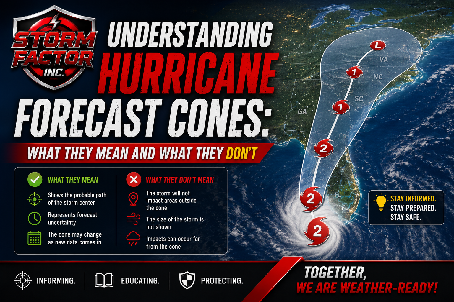
Understanding Hurricane Forecast Cones: What They Mean and What They Don’t
As hurricane season gets underway, one of the most widely shared graphics from the National Hurricane Center is the forecast cone. While many people see these maps on television, social media, and weather websites, there are still common misconceptions about what the cone actually represents.
Understanding the hurricane forecast cone can help you make better decisions and avoid dangerous assumptions when tropical weather threatens your area.
What Is the Hurricane Forecast Cone?
The forecast cone, officially known as the “Cone of Uncertainty,” is a graphic that shows the probable track of the center of a tropical cyclone over the next several days.
The cone is created using historical forecast errors from previous storms. Because forecasts become less certain farther into the future, the cone widens with time.
The center of the storm is expected to remain somewhere within the cone approximately two-thirds of the time based on historical forecast accuracy.
Common Myth: Impacts Only Occur Inside the Cone
One of the most dangerous misunderstandings is believing that if your location is outside the cone, you are safe from impacts.
This is not true.
The cone only tracks the probable path of the storm’s center. Hurricane-force winds, tropical-storm-force winds, heavy rain, flooding, tornadoes, and storm surge can occur far outside the cone.
In many cases, impacts extend hundreds of miles from the center of circulation.
Remember:
- The cone is not a wind forecast.
- The cone is not a rainfall forecast.
- The cone is not an impact forecast.
- The cone only represents the likely path of the storm’s center.
Why the Cone Gets Larger Over Time
Weather forecasts become less certain the farther into the future meteorologists look.
Small changes in atmospheric conditions can cause a storm to track differently over several days.
As a result, forecast confidence decreases with time, causing the cone to widen from day one through day five or seven.
This widening does not necessarily mean the storm is getting larger. It simply reflects increasing uncertainty in the forecast track.
The Center Line Can Be Misleading
Many people focus on the line running down the middle of the cone and assume that is exactly where the storm will travel.
In reality, the center line represents the most likely forecast track at that moment, but storms often deviate from that line.
Residents throughout the cone should prepare for possible impacts, not just those directly under the forecast center line.
Storm Size Matters
A large hurricane can produce impacts over a much wider area than a smaller storm.
For example:
- A compact hurricane may have damaging winds confined relatively close to its center.
- A large hurricane may spread tropical-storm-force winds across several states.
- Heavy rainfall and flooding can occur far inland, well away from the coast.
Always pay attention to the storm’s forecast wind field and hazard outlooks in addition to the cone.
Focus on Hazards, Not Just the Track
Emergency managers and meteorologists increasingly emphasize a hazard-based approach to tropical weather preparedness.
Instead of asking:
“Am I inside the cone?”
Ask:
- Could I experience storm surge?
- Am I in a flood-prone area?
- Could tropical-storm-force winds impact my community?
- Are tornadoes possible from outer rain bands?
- Do I have a preparedness plan if conditions worsen?
These questions provide a much better assessment of risk than simply looking at the forecast track.
What You Should Do When a Hurricane Threatens
- Monitor forecasts from trusted sources.
- Review your emergency plan.
- Check your disaster supply kit.
- Know your evacuation zone if you live near the coast.
- Stay informed of watches and warnings.
- Never focus solely on the center line or cone boundaries.
Final Thoughts
The hurricane forecast cone is an important forecasting tool, but it is often misunderstood. The cone does not show where impacts will occur—it only illustrates the probable path of the storm’s center.
When tropical systems threaten the United States, residents should focus on all hazards associated with the storm, including wind, flooding rainfall, tornadoes, and storm surge. Conditions can become dangerous well outside the forecast cone.
This hurricane season, remember: Don’t focus on the line. Focus on the impacts.
Storm Factor Safety Message:
Prepare before a storm is approaching. Build an emergency kit, review your family’s communication plan, and stay weather-aware throughout hurricane season. A few hours of preparation today can make a significant difference when severe weather threatens tomorrow.